468x80 Banner

Collapse

Announcement

Collapse
No announcement yet.

Satellite Photos Post Ike

Collapse
X
 
  • Filter
  • Time
  • Show
Clear All
new posts

  • Satellite Photos Post Ike

    Let me know if yall want a specific area...
    Attached Files
    We are West End Anglers, a saltwater tribe!

  • #2
    Deer Island & Meacoms...
    Attached Files
    We are West End Anglers, a saltwater tribe!

    Comment


    • #3
      Bolivar... DAMN!!!

      Before & After photos... Same area! WOW!
      Attached Files
      We are West End Anglers, a saltwater tribe!

      Comment


      • #4
        TX City Dike...

        Here you go Tiny...
        Attached Files
        We are West End Anglers, a saltwater tribe!

        Comment


        • #5
          SLP Before and After

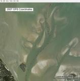
          The first attached image shows my GPS MOB coordinates that I marked on Google Earth in 2007 showing the boat's path through San Luis Pass. The second attached image is a satellite image of SLP after Hurricane Ike, in which I superimposed the coordinates from the 2007 image. The pass doesn't look much different. I was thinking that a hurricane, even a Cat 2, would have changed SLP much more than it was by Hurricane Ike.


          Attached Files

          Comment


          • #6
            do you have any of alligator head/halls lake?? thanks in advace
            Boats and hoes.

            Comment


            • #7
              Coe, show the Starvation Cove/Geo Tube area. Thanks, Mell

              Comment


              • #8
                Dude, This is awesome! Thanks for the closeups of our place!
                From 1970-1997, true heaven on Earth existed on the banks of Bayou Cook. "Hey Dad, Thanks for buying the Camp."

                Comment

                Working...
                X